The development of our society and the current model of producing goods are increasingly being called into question by the numerous crises that upset the contemporary world. Faced with an increase in the world population, and therefore in the food needs to be met, the sustainability of the agricultural sector appears increasingly fragile. This system is subjected to continuous stress from various factors: droughts, caused by climate change, put at serious risk the availability of water for agricultural uses; at the same time, the crisis in the supply chain of raw materials, one of the consequences of the Russian-Ukrainian conflict, is also pushing towards a limitation in the use of fertilisers, which are of fundamental importance for agriculture. What is known as “precision agriculture” plays a key role in reducing the waste of these precious resources and, therefore, in moving towards a more sustainable model of agricultural production in the long term. The widespread application of sensors that monitor the state of soils and vegetation provides detailed, real-time knowledge of agricultural land, thus making it possible to optimise the distribution of resources (water and fertilisers, to be precise) according to the point-by-point health of the land itself. The interest surrounding this sector is also confirmed by the updates in the European regulatory framework for agriculture, with the elaboration of the European Green Deal plan and with the definition of the Common Agricultural Policy, which have allocated 387 billion euros to innovative agricultural projects.
GENUINE was developed to offer a new solution in the precision agriculture field. The idea is based on the synergy between technological sectors that have seen great development in recent years, such as positioning and navigation systems (GNSS), remote sensing and artificial intelligence. The main goal of the project is, in fact, to exploit these technologies to deliver a representation of agricultural land that highlights the areas subjected to greater stress, as well as to guide agricultural machinery when operating in these areas.
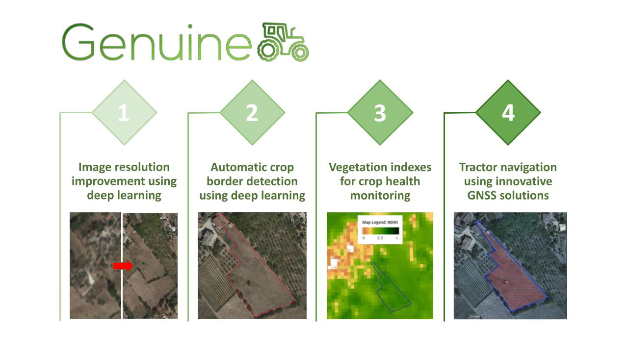
Firstly, the solution aims to optimise medium-high-resolution (5-10m) satellite images, such as, for example, those acquired by the satellites of the Sentinel-2 mission, through super-resolution deep-learning algorithms. This kind of imagery is not sufficiently detailed to fall within the set of precision agriculture resources and technologies; however, by processing the raw images through super-resolution algorithms, GENUINE is able to obtain higher-quality data, which offers two advantages for users: a limited cost due to the possibility of using free images, and the absence of the burden of having to acquire the data personally or with the help of experts (such as images acquired by drone).
Secondly, the solution includes further processing of the upsampled satellite images: through crop border detection by means of deep learning algorithms with the aim of isolating the field of interest from the rest of the image; and by combining the bands of the images themselves to calculate indicators of the vegetation health or vegetation indices.
Once these products have been obtained, the areas of agricultural land requiring the most urgent intervention are identified.
In the third and final step, once the region in which the agricultural machine must operate and its path have been defined, an algorithm to process GNSS data is added, allowing the vehicle to travel the route with high precision.
Finally, the proposed solution is modular, in the sense that it is designed both as a complete pipeline and as a set of functionalities that can be used separately by the user.
How GENUINE started
The idea behind the GENUINE team was developed by a group of eight researchers and PhD students from the Geodesy and Geomatics Division at Sapienza University of Rome. The project was successfully submitted to two competitions aimed at promoting the maturation of innovative ideas.
An initial version of the solution, which exclusively included the GNSS module to optimise the movement of the agricultural machinery, was submitted to the “Farming by Satellite 2020” competition, organised by the European GNSS Agency (GSA), and was awarded the second prize, which supported the development of a prototype.
Starting from this initial core, a new proposal was elaborated, which added functionalities to the GNSS module based on super-resolution algorithms. The new idea was then submitted to the Copernicus Masters 2021 competition and was announced as the winner of the Copernicus Regional Prize Italy. This award was of fundamental importance for the further refinement of the project and provided a basis for the possible foundation of a startup in the near future. The following six-month collaboration with the Italian Space Agency (ASI) and the partner Infinite Area allowed the developers to draft a more structured business plan and provided knowledge of the status of competing solutions. Furthermore, it was possible to enter into a direct dialogue with the stakeholders in the precision agriculture sector with the opportunity to interact with business angels, representatives of agricultural machine manufacturers (such as CNH Industrial or Bassan), and technical experts in precision farming.
These discussions and brainstorming sessions offered great value, not only for refining the initial idea, which was brought to a higher level of maturity, but also to significantly increase the project team’s knowledge. Composed exclusively of engineers and data scientists from the academic world, the team has greatly benefitted from contact with the realities of production and business, as well as with economics experts. A fundamental legacy of GENUINE’s path has undoubtedly been the awareness that effective solutions to tackle the complex problems of today’s society cannot ignore the intersection between different disciplines: the expansion of the GENUINE team in this sense is therefore one of the main goals for the further development of our idea.
About the Author

After a master’s degree in Environmental Engineering, Lorenzo Lastilla defended his PhD in Data Science in 2022. In 2020, together with a group of colleagues from the Area of Geodesy and Geomatics of Sapienza University of Rome, he developed GENUINE, a new solution for precision agriculture based on satellite data.


