
Water is the most important resource on the planet, not only for life itself but also for many human activities that rely on water for their daily operations.
How much water is there? And when will it become available?
The answer to these questions is crucial to optimise water resources and anticipate possible extreme events. Climate change, however, is becoming a real threat, making water resources ever more discontinuous and increasing the frequency of extreme events.
The current approach used by many companies to predict water resources is still based on empirical tools, such as the historical mean, which purely relies on historical data without taking into consideration the actual condition of the catchment and the meteorological forecasts for the coming days or months. This approach may lead to inefficiencies or, even worse, to severe impacts from water shortages or floods.
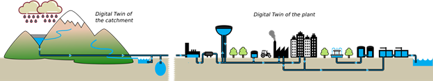
To overcome these problems and take climate change into account, MobyGIS has developed Waterjade®, a new technology that aims to create the digital twin of the catchment to provide accurate forecasts on water availability.
Many industrial companies can benefit from this technology. For example, water utilities can optimise water withdrawal in order to always meet the demand for water and hydropower companies may optimise the level of the reservoirs and energy trading according to an accurate prediction of water inflow.
Technology
The technology is based on a core analysis of hydro-meteorological observations obtained from in situ stations that feed a physical model to simulate the complete water cycle at the basin scale. Satellite data are used to initialise the system and to overcome any missing observations, and machine learning models are used to process the data and extract the maximum information content. Finally, numerical weather predictions are used to predict the evolution of the catchment, in terms of precipitation, snowmelt and evapotranspiration, and thus calculate the most likely forecast of water inflow in the production plants.
All the results are embedded in an online platform that can be accessed by users. After an initial system configuration where the catchment geometry is defined and the hydraulic connections set up, it is possible to activate the required services, such as monitoring services (e.g. snow monitoring, and discharge monitoring in given outlets), and forecasting services, such as short-term (+5 days) predictions and seasonal (+6 months) forecasts. A decision support service is also available to simulate the reservoir level on the basis of the forecasts and management decisions.
Example: snow monitoring
Snow is a crucial variable that affects the storage of water resources. Not only does it enable outdoor activities, such as skiing, which are a key source of income for many Alpine valleys, but it also acts as a source of water that feeds the downstream water resources. Four of the major European rivers (namely Rhine, Danube, Rhône and Po) originate in the Alps, which for this reason, are often called the “water tower” of Europe.
How much snow is stored in the Alps? How is the snow evolving in time and space?
These are the questions that we are addressing through the snow monitoring service implemented in Waterjade®. The service quantifies the snow water equivalent (SWE) at the catchment scale for different elevation ranges. The information is updated on a weekly basis and has the advantage that no measurement campaign is required.
The service makes use of high-resolution satellite maps from the Sentinel-2 mission. These optical products allow the extraction of snow-covered area (SCA) information to be later assimilated by a physical model in order to improve the accuracy in terms of snow cover and snow melting.
Hydropower companies can use the snow water equivalent (SWE) to calculate the mass of water (and eventually of energy) currently stored upstream of their plants. Public agencies may follow the evolution of the snowpack in order to manage the avalanche risk and to monitor the water balance at the basin scale. Ultimately, ski resorts and outdoor explorers are better able to plan off-piste excursions while taking the avalanche risk into account.
The eo4alps snow project
We are happy to announce that MobyGIS leads the consortium, together with EURAC research (IT) and Sinergise (SI), that has won the ESA tender to produce daily updated high-resolution SWE in the Alps. The project, called eo4alps snow, was officially kicked off on 28 January 2021 and will run for a total of two years. This project will further improve the accuracy by combining several satellite products (Sentinel-1, Sentinel-2 and Sentinel-3).
About the author:

Matteo Dall’Amico (founder and CEO):
Degree in Engineering (1999, University of Padua), Master in Soil Defence and Civil Protection (2004, University of Padua), Ph.D. in Environmental Engineering (2010, University of Trento). Since 2010, he has been collaborating with several avalanche centres in the Italian Alps to provide a dynamic snow map to improve the forecasting system for avalanche danger. In 2013-2014, he was involved in the Water Platform of the Alpine Convention, collaborating in the drafting of guidelines for the application of EU Directives 2000/60 and 2007/60 and plans to adapt to climate change. In 2015, he founded MobyGIS: initially, through the project Mysnowmaps®, to provide snow maps for the outdoor sector. In 2017, through Waterjade®, he targeted industrial operators with customized forecasting services to optimise water abstraction.


