According to current estimates of the Food and Agriculture Organization of the United Nations, the world’s population will grow to 9.7 billion people by 2050, requiring a 60% increase in food demand compared to 2005. At the same time, global climate change, demographic developments, increasing soil erosion and poor resource management are exerting increasing pressure on global agriculture.
Accurate forecasting of regional and national crop yields is a necessity to enable corporations, NGOs (non-governmental organisations) and governments to respond and take action in a timely manner against the effects of such events. This includes short-term planning of irrigation, fertiliser and plant protection management, medium-term logistics to replenish supplies in affected areas, as well as early payment of insurance premiums for crop losses to mitigate humanitarian disasters.
The 2019 Copernicus Masters ESA Challenge Winner ConstellR’s declared long-term goal is to answer the emerging need for global crop monitoring services. As a basis for such services, the company will complement the Copernicus programme with thermal infrared (TIR) imaging capabilities at high spatial resolution and short revisit times.
Imaging Capabilities
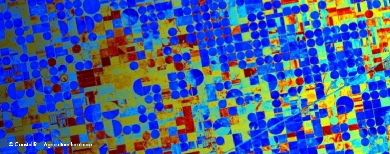
Current satellite systems have highly evolved imaging capabilities in the visual and radio spectra, but they are not well-suited for crop monitoring. For proper crop monitoring, ConstellR needs to take the plant’s temperature, ideally daily and on the level of a single field. The Sentinel-3 A/B of the Copernicus programme are currently delivering 1 km ground resolution Land Surface Temperature (LST) data twice a day. While offering diurnal observational capabilities and very precise temperature readings, the coarse spatial resolution puts a massive constraint on the development of respective Earth observation (EO) applications depending on high-resolution data.
ConstellR’s concept is a cost-effective and easily scalable approach based on an advanced CubeSat architecture in combination with a cooperative operational approach between TIR CubeSats with existing space infrastructure. Specifically, the entrepreneurs plan to provide LST data and derived products with daily, global coverage, 50 m spatial resolution, and a radiometric accuracy comparable to Sentinel-3. Compared to the existing approach and systems, this would offer comparable performance at 97% reduced costs.
Sustainable agriculture in order to ensure food security for humankind
ConstellR provides a technological cornerstone to reach two of the UN SDGs: Zero Hunger and Clean Water and Sanitation. One of the biggest challenges for today’s agriculture is the enormous water consumption caused by artificial irrigation and this also is the biggest cost factor: Worldwide, it accounts for 70% of freshwater abstraction from rivers, lakes and groundwater. The growing water demand of cities and industry and increasing environmental pollution will greatly reduce the amount of water available for agriculture in many regions.
In many places, current irrigation practice is unregulated, which means that in most cases significantly more water is used than is necessary for optimum plant growth. Studies assume that up to 50% of the water used is wasted in this way. If current practices are maintained, the volume of water supply in plant and livestock production worldwide would have to increase substantially by 2050 to keep pace with rising demand.
Precise irrigation systems to save water
Precise irrigation systems (PIS) can significantly reduce the amount of water used per agricultural area while maintaining or even increasing yield. The water saved can be used to irrigate other agricultural land, thereby increasing the overall yield. PIS are characterised by the fact that they continuously add small amounts of water to the soil directly at the crop. This prevents inefficient evaporation and seepage. The saved water can be used for further irrigation of additional fields, drinking water supply or other necessary services.
To determine the amount of water needed, continuous measurements of soil moisture are necessary. Soil moisture can be directly derived from the TIR remote sensing data provided by ConstellR, making an important contribution to agricultural information management. The estimation of evapotranspiration (ET), again based on TIR data, describes the loss of water to the atmosphere. It is composed of evaporation, representing the loss of moisture content from the upper layers of the Earth, and plant transpiration, which is closely correlated with the water content in the deeper root layer. ET is therefore the key variable for globally applicable guidelines for farmers to increase efficiency on agricultural land and save costs. In addition, this information helps to improve crop yield models, mitigate commodity price fluctuations and thus prevent humanitarian disasters.
ConstellR – active contribution to global food security
This information will support governments and NGOs to respond early to environmental disasters, such as droughts, by adapting water management and food supply planning. The data provided by ConstellR can thus make an active contribution to global food security, mitigating the effects of extreme weather and climate events as well as related consequences. In addition to the market for agricultural information and analysis, the 2019 Copernicus Masters ESA Challenge Winner cooperates with companies from various sectors, such as the insurance markets, urban and infrastructure monitoring, raw material search, fire detection, health management, and geoanalytics.
Satellite systems
Of course, one can argue that there are other ways to get this data: Sensors could be installed in fields (i.e. IoT solutions) or drones could be used. However, given the fact that around 1.4 billion hectares of agricultural land would then have to be cultivated worldwide and by 2050 most of the world’s food would be produced in sub-Saharan and South America, satellites are the only possible approach to date. But why hasn’t it worked with existing satellite systems so far?
At costs of several hundreds of millions to one billion euros per satellite, current satellite systems capable of delivering the needed TIR data are very expensive to develop and operate, especially when operated in a constellation.
Hence, the ConstellR approach foresees the cooperative use between low-cost CubeSats and existing satellite infrastructure to realise global, high-resolution and precise temperature monitoring. In the future, the company plans to install a constellation of CubeSats to measure the surface temperature of Earth in short time intervals. In total, they aim at a spatial resolution of about 50 m, a temperature accuracy on the ground of better than 1.5 K – depending on atmospheric conditions – and a scalable revision time (globally averaged) of 24 h or shorter. To reach this goal, the ConstellR team developed an interwoven technical approach, making use of bleeding-edge technology from Fraunhofer and the German Aerospace Center (DLR). Furthermore, the firm has been working with OHB System AG, one of the three major European space integrators, since 2017. OHB is supporting the team in the design and development of the complex space optics. In addition, ConstellR is cooperating with the Lithuanian CubeSat integrator NanoAvionics, which will provide the satellite bus and other experts in the New Space market.
Taken together, the on-board technology is coordinated in such a way that the CubeSats can take over the tasks that previously required large satellite platforms with almost no loss of performance.
ConstellR Copernicus Masters ESA Challenge Winner
In 2019, ConstellR was announced as the ESA Challenge Winner of the leading Earth observation innovation competition Copernicus Masters. ConstellR is a joint spin-off from Fraunhofer and DLR. Specifically, the Fraunhofer Ernst Mach Institut (EMI) provides the needed infrastructure and technological know-how for the mission design and operations and is complemented by DLR’s Institute for Optical Sensor Systems’ (OS) expansive background in infrared imaging.
ConstellR’s founding team Max Gulde (CEO) and Marius Bierdel (CTO) are both based in Freiburg at Fraunhofer EMI, Christian Mittermaier (CFO) at the TU Munich and Christian Williges (COO) at Berlin’s DLR OS.
Today, the entrepreneurs are funded by the German Federal Ministry of Economics and Energy (BMWi) via the EXIST programme. With the support from Airbus and the European Space Agency (ESA), ConstellR will launch an in-orbit demonstrator by next year.
In terms of business, the team has succeeded in achieving its first market traction with the currently non-public EO searching & forecasting platform, which is opening up new business opportunities in this market.
About Christian Williges:
 Christian is the COO of ConstellR and develops the foundation to provide precise thermal EO imagery. He has a strong background in the development and verification of space-borne optical sensor systems and is a project manager for international EO projects. To cope with the stress, he spends his nights as a superhero.


