Background and Motivation
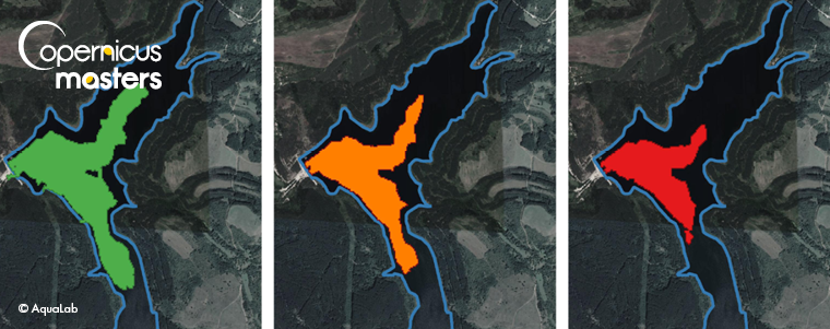
Water monitoring is very important for the national security of any state. Water reservoirs are designed to provide water that is vital for freshwater supply and irrigation purposes. Without a doubt, water has become the new gold of the 21st century. In 2019, more than 100,000 inhabitants in Bulgaria were left without running water for more than 6 months due to unnoticed low levels in the Studena reservoir (see Figure 1). Judging by Sentinel-2 data from 2019, the water had begun mysteriously drying out in the summer but, unfortunately, it was only noticed in November. This late response led to a water crisis that lasted for 6 months. If only there had been a web-based GIS showing the current water status at that time, the crisis could have been prevented.
Moreover, in 2020, Europe was struck by the highest temperatures ever and droughts prevailed throughout Central Europe.
Our team of geodetic engineers was prompted and persuaded to create a dynamic GIS for water management, not only to improve the freshwater supply but also to preserve natural water resources. The greatest objective was to create a dynamic web-based GIS for water management.
Winner of the 2020 DLR Environment, Energy & Health Challenge
The Bulgarian team from MAP.ING created AquaLab to observe water reservoirs with EO data. AquaLab is a web-based geographic information system that offers dynamic geospatial information about water reservoirs. The idea behind the project was pitched during the Copernicus Master 2020 in the Environment, Energy & Health Challenge by DLR. The goals of the project complied with the DLR requirements and the team was awarded the Challenge Winner title during the online Space Awards in December 2020. The team is focused on how to raise awareness among Bulgarians about earth observation data and how beneficial it could be when monitoring the environment.
Goals and milestones
The topic of water management is really popular and important. Many state and local institutions are in charge of freshwater supplies. The MAP.ING team was eager to present a relatively new method of water monitoring by using earth observation data (mainly open source) and use a new computational methodology in order to provide a product with added value. So, the first goal that the team set was to establish communication between institutions and engineers. The second was to not only present the current status of water bodies but also to notify the interested community. AquaLab is designed to play the role of an online data storage where vector and metadata of water reservoirs would be kept. Hopefully, the project will raise awareness among the hydraulic community and the institutions involved, which will encourage them to digitize and share valuable existing data on water reservoir monitoring.
Who would benefit from using AquaLab?
The project is designed to benefit society and hydraulic experts. AquaLab will provide free monthly notifications of the recent state of any water reservoir. The project focuses on raising awareness of the water supply within society.
Engineers will no longer use old map layers to design future water reservoirs, but will now be provided with up-to-date multispectral and elevation satellite data.
The project is based on Copernicus radar and optical data from Sentinel-1 and Sentinel-2. We created an algorithm to calculate the water surface area based on water indices.
The project goals are achieved using radar and optical data from Sentinel-1 and Sentinel-2.
The AquaLab’s main geo-products are in the form of statistical models of the surface water area, and free monthly notifications indicating dead, retention and full water volume. We plan to integrate in-situ data and satellite measurements in order to calculate water volumes.
Future aims
Monitoring bodies of water plays an important role in the national security of the state. AquaLab is focused on improving local water management issues in Bulgaria. Despite that, the topic of water management will be of a high importance over the next decade or even longer. That is why the team’s greatest ambitions are to create a web-based platform for water reservoir monitoring across the whole of Europe.
About the Author & Team
 Paulina Raeva, CEO and Co-founder of MAP.ING Ltd.
Team MAP.ING is currently working on optimising its platform and hopes AquaLab will be a great asset to specialists and to the general public. The team consists of geodetic and IT engineers. The company intends to start a business in remote sensing and GIS using mainly open-source data and software to create added value for its geo-products.


Comments are closed.